
- 396 words
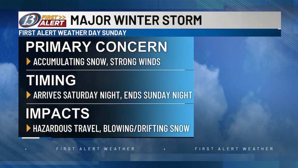
A major late-season winter storm will bring hazardous travel conditions across the Upper Midwest this weekend, with significant snowfall accumulations and strong winds creating dangerous road conditions.
The First Alert Weather team has declared Sunday a First Alert Weather Day due to the expected major impacts.
What to Expect
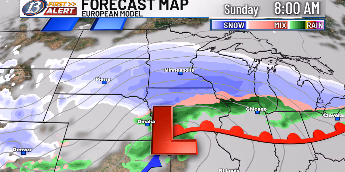
The storm system will begin to push into the region Saturday, as clouds spread across the Upper Midwest throughout the day. Conditions should remain dry through the afternoon, before snow chances begin to increase.
Snow will begin to develop through the evening—and continue through much of Sunday. The snow will start off a little on the wet side, with temperatures in the 20s to around 30 degrees.
Strong northeast winds of 15 to 30 mph will accompany the snow, creating significant blowing and drifting. This combination will make travel particularly hazardous throughout the day Sunday.
Where the Storm Packs the Most Punch
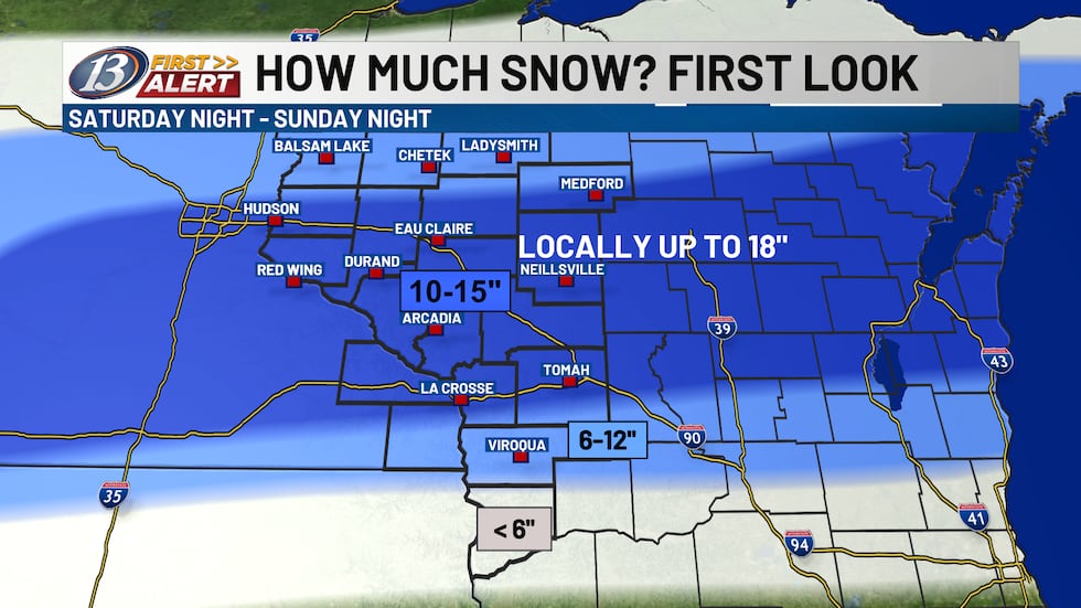
The area from the I-94 corridor south through the I-90 corridor is currently expected to be in the high-impact zone, with the heaviest snow expected somewhere along or between these routes. Forecast models have come into better agreement on the track and intensity. Several inches are likely, with double-digit totals expected in that zone. Below is a first look snowfall forecast. As always, it’ll be updated as we get more information and inch closer to the event.
The National Weather Service has also placed the entire area under a Winter Storm Watch from Saturday night into Monday morning.

Planning Ahead
If you have travel plans this weekend, especially Sunday, monitor the forecast closely for the latest information. Conditions will deteriorate quickly once snow develops Saturday night.
This is a typical Colorado low-pressure system that will cross the Plains before moving northeast through the Midwest. The system will strengthen quickly while pulling high amounts of moisture up from the south, making this a significant weather event.
Stay Weather Aware
For the latest updates and hour-by-hour details, check out the First Alert Weather page at weau.com or download the 13 First Alert Weather app. We’ll be updating forecasts frequently as this system approaches.
Copyright 2026 WEAU. All rights reserved.
Author
Related Posts
ICE shooting in Patterson, CA, sends person to hospital
Sperry Avenue is closed between Rogers Road and the Interstate 5 exit in Patterson as an ICE-involved shooting is investigated on Tuesday,...
Read out all
Texas Gov. Greg Abbott and Gov. Ron DeSantis to speak in Miami
MIAMI, Fla. (CBS12) — Governor Ron DeSantis is set to speak in Miami with Texas Governor Greg Abbott on Tuesday morning. According...
Read out all
Iran war: What is happening on day 39 of US-Israeli attacks? – Al Jazeera
Iran war: What is happening on day 39 of US-Israeli attacks? Al Jazeera As Iran war enters 6th week, escalation looks the most...
Read out all
US mortgage rates climb for fifth-straight week, pushed up by Iran war worries
Average US mortgage rates climbed again for the fifth week in a row, making homebuying more expensive than it was just a...
Read out all‘Charlie’s Angels’ turns 50 – See photos of the original cast
Updated April 6, 2026, 4:27 p.m. ET The original “Charlie’s Angels” is turning 50. Farrah Fawcett, left, Kate Jackson, center, and Jaclyn...
Read out all