
Our current stretch of heat will peak Monday and bring strong thunderstorms back to parts of Iowa. A Tornado Watch is in effect until 10 p.m. for much of central Iowa, including the Des Moines metro and most of eastern Iowa.Here’s what to expect:Widespread heat indices of 100-105 degrees Monday afternoonMore storms cross Iowa late Monday afternoon/eveningSevere weather is possible during the evening hours Baseball-sized hail reported Heat and humidity intensify Monday afternoon A Heat Advisory will be in effect for most areas until 8 p.m. Monday.Temperatures will surge into the mid-90s, while humidity increases to tropical levels. Expect the heat index to be around 105 degrees at times through early evening.Storms fire this afternoon and eveningStrong to severe storms are likely by Monday afternoon and evening.These will fire ahead of a front coming into northern/northwest Iowa during the early afternoon. Storms could ignite as soon as 2-4 p.m., then become more widespread into the evening hours. Severe weather is more likely with this round than the storms in eastern Iowa earlier today.Damaging wind gusts are the main threat from these storms as they move southeast Monday evening. Large hail is possible, too. A tornado isn’t out of the question especially across eastern portions of Iowa.More smoke possibleThunderstorms should knock down the worst of eastern Iowa’s wildfire smoke lingering from Sunday.The bad news is that a veil of smoke might follow Monday night’s cold front into Iowa.Smoky haze currently up in North Dakota, Montana, and Canada looks to flow southward toward Iowa overnight Monday into early Tuesday.It’s possible this band of smoke passes all the way through Iowa before the sun rises Tuesday, but some haze could linger into the morning, especially southern parts of the state. This smoke should not be as thick as what affected the state on Sunday.
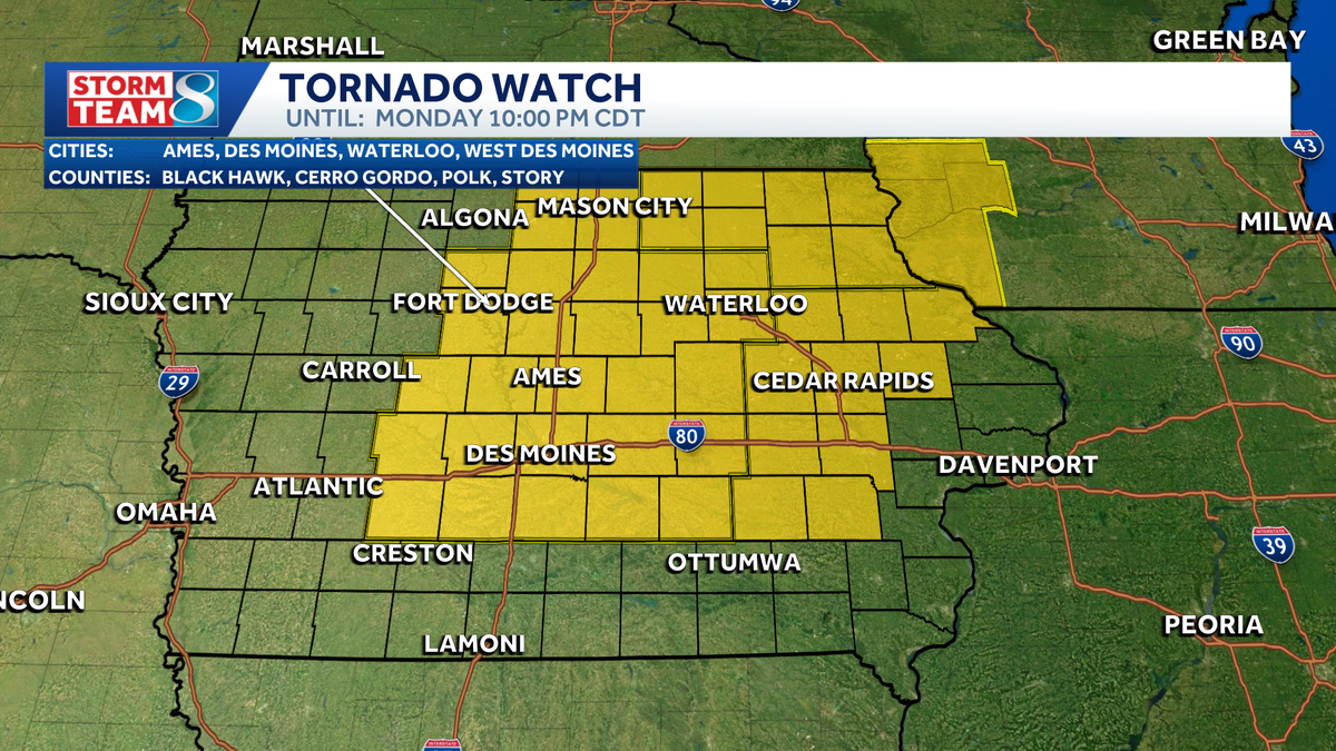
Our current stretch of heat will peak Monday and bring strong thunderstorms back to parts of Iowa. A Tornado Watch is in effect until 10 p.m. for much of central Iowa, including the Des Moines metro and most of eastern Iowa.
Here’s what to expect:
- Widespread heat indices of 100-105 degrees Monday afternoon
- More storms cross Iowa late Monday afternoon/evening
- Severe weather is possible during the evening hours
Baseball-sized hail reported


Heat and humidity intensify Monday afternoon
A Heat Advisory will be in effect for most areas until 8 p.m. Monday.


Temperatures will surge into the mid-90s, while humidity increases to tropical levels. Expect the heat index to be around 105 degrees at times through early evening.
Storms fire this afternoon and evening
Strong to severe storms are likely by Monday afternoon and evening.
These will fire ahead of a front coming into northern/northwest Iowa during the early afternoon.

Storms could ignite as soon as 2-4 p.m., then become more widespread into the evening hours.
Severe weather is more likely with this round than the storms in eastern Iowa earlier today.

Damaging wind gusts are the main threat from these storms as they move southeast Monday evening. Large hail is possible, too. A tornado isn’t out of the question especially across eastern portions of Iowa.
More smoke possible
Thunderstorms should knock down the worst of eastern Iowa’s wildfire smoke lingering from Sunday.
The bad news is that a veil of smoke might follow Monday night’s cold front into Iowa.

Smoky haze currently up in North Dakota, Montana, and Canada looks to flow southward toward Iowa overnight Monday into early Tuesday.
It’s possible this band of smoke passes all the way through Iowa before the sun rises Tuesday, but some haze could linger into the morning, especially southern parts of the state. This smoke should not be as thick as what affected the state on Sunday.


