

Severe storms are firing off across parts of Oklahoma with a severe thunderstorm watch issued.
>> Go to the KOCO weather page | Get KOCO on the Go | Subscribe to KOCO 5’s YouTube channel | Sign up for KOCO 5’s Morning Newsletter
Below is a running blog from Friday’s storms
5:40 p.m. Friday Update:
The National Weather Service has issued a severe thunderstorm warning for southwestern Comanche County, northwestern Cotton County, south central Kiowa County and northeastern Tillman County.
The main threats with the storms are 60 mph wind gusts and hail the size of quarters.
Areas that could be impacted include western Lawton, Cache, Snyder, Chattanooga, Mountain Park, Indiahoma, Faxon, and southwestern Fort Sill.
The warning is set to expire at 6:15 p.m.
5:25 p.m. Friday Update:
The National Weather Service has issued a severe thunderstorm warning for southeastern Noble County and northeastern Payne County.
The main threats with the storms are 60 mph wind gusts and hail up to the size of quarters.
Areas that could be impacted include Stillwater, Yale, Morrison, Glencoe, Quay, and Ingalls.
The warning is set to expire at 6:15 p.m.
5:12 p.m. Friday Update:
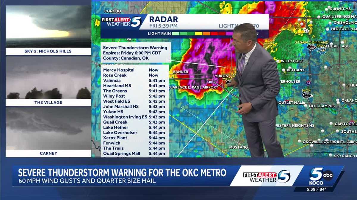
The National Weather Service has issued a severe thunderstorm warning for southeastern Kingfisher County, Oklahoma County, southern Logan County and northeastern Canadian County.
The main threats with the storms are 60 mph wind gusts and hail the size of half dollars.
Oklahoma City, Edmond, Midwest City, Del City, El Reno, Guthrie, Kingfisher, Yukon, Bethany, Mustang, Warr Acres, The Village, Piedmont, Spencer, Nichols Hills, Jones, Okarche, Cashion, Calumet, and Cedar Valley.
The warning is set to expire at 6 p.m.
5 p.m. Friday Update:
The National Weather Service has issued a severe thunderstorm warning for northwestern Lincoln County, northeastern Logan County and southwestern Payne County.
The main threats with the storms are 60 mph wind gusts and hail up to the size of half dollars.
Areas that could be impacted include Perkins, Langston, Tryon, Ripley, Agra, Coyle, Mulhall, Meridian, and Parkland.
The warning is set to expire at 5:45 p.m.
4:35 p.m. Friday Update:
The National Weather Service has issued a severe thunderstorm warning for southern Kingfisher County, east central Blaine County and north central Canadian County.
The main threats with the storms at wind gusts up to 60 mph and hail the size of quarters.
Areas that could be impacted include Watonga, Kingfisher, Okarche, Hitchcock, and Omega.
The warning is set to expire at 5:15 p.m.
4:30 p.m. Friday Update:
The National Weather Service has issued a severe thunderstorm warning for east central Kingfisher County, southwestern Noble County, northern Logan County and southwestern Payne County.
The main threats with the storms are 60 mph wind gusts and hail the size of quarters.
Areas that could be impacted include Langston, Crescent, Coyle, Mulhall, Orlando, Lovell, and Lake Carl Blackwell.
The warning is set to expire at 5 p.m.
3:45 p.m. Friday Update:
The National Weather Service has issued a severe thunderstorm warning for eastern Kay County and north central Noble County.
The main threats with the storms are 60 mph wind gusts and hail the size of quarters.
Areas that could be affected include Ponca City, Kaw City, Kildare, and Kaw Lake.
The warning is set to expire at 4:30 p.m.
2:55 p.m. Friday Update:
The National Weather Service has issued a severe thunderstorm watch until 10 p.m. for Atoka, Blaine, Bryan, Caddo, Canadian, Carter, Cherokee, Cleveland, Coal, Comanche, Cotton, Craig, Creek, Custer, Delaware, Dewey, Garfield, Garvin, Grady, Hughes, Jefferson, Johnston, Kay, Kingfisher, Kiowa, Lincoln, Logan, Love, Major, Marshall, Mayes, McClain, McIntosh, Murray, Muskogee, Noble, Nowata, Okfuskee, Oklahoma, Okmulgee, Osage, Ottawa, Pawnee, Payne, Pittsburg, Pontotoc, Pottawatomie, Rogers, Seminole, Stephens, Tillman, Tulsa, Wagoner, Washington and Washita counties.
KOCO 5 Meteorologist Mikayla Smith shows what you need to know before the storms.
Friday Storm Risk
A level 2 slight risk has been issued for much of Oklahoma spanning from the southwestern to the eastern part of the state. The OKC metro is included in the slight risk zone.
There’s also a level 1 marginal risk in far eastern and parts of western Oklahoma.
Storms could produce 2-inch hail and damaging 60-70 mph wind gusts, and there’s a low tornado risk.

Oklahoma Tornado Risk
The tornado index is highest in central and northeastern Oklahoma, sitting at a 2 out of 10. This zone includes the OKC metro, Enid, Stillwater, Seminole, Tulsa, Ponca City, Bartlesville, and areas east of Hobart and Clinton, and northeast of Lawton.
Surrounding areas in the severe weather risk zone have a tornado index of 1 out of 10.
The tornado threats will be possible, but the bigger concern is going to be strong winds and hail.

Oklahoma Hail Risk
We’re watching for some damaging hail with these storms. Central, southwestern, and northwestern Oklahoma – including the OKC metro, Lawton, Ada, Ardmore, Enid, Seminole, Stillwater, Tulsa, Ponca City, and Bartlesville – could see golf ball-sized hail.
Not every storm in that area will have golf ball-sized hail. Surrounding areas could get hail the size of quarters.

Severe Storm Timeline
These storms could impact your evening plans, with storms possibly firing up north of the OKC metro by 3 p.m. Friday. They’ll develop and travel south and east into the OKC and Tulsa metros, Stillwater, Shawnee, El Reno, and Hinton by 5-6 p.m.
Once they pass the metro by 7 p.m., they’ll continue south toward Pauls Valley and Purcell and then to the Texas border by 9 p.m. Friday. The storms will be out of Oklahoma after midnight.

Saturday Storm Risk
Storm chances are really low throughout the day, but they ramp up Saturday night and into the overnight hours into Mother’s Day.
There’s another level 2 slight risk for southwestern Oklahoma on Saturday. Areas included in this risk zone are Clinton, Hobart, Altus, and Lawton.
A level 1 marginal risk also has been issued for central, northwestern and southern Oklahoma as well as the Panhandle. The OKC metro is included in this risk zone.
These storms could produce hail and damaging winds, and there’s also a low tornado risk.

KOCO 5 First Alert Weather Team, led by Chief Meteorologist Damon Lane, has been certified by WeatheRate as providing the Most Accurate Forecast in Oklahoma City for 14 consecutive years. This outstanding achievement underscores KOCO 5’s unwavering dedication to delivering reliable weather forecasts to viewers.


