
- 717 words
HONOLULU (HawaiiNewsNow) – Your First Alert Weather Team has declared FIRST ALERT WEATHER DAYS through Saturday as a large and powerful Kona storm moves north of the state and continues to pull up deep tropical moisture and heavy rain at times over Hawaii.
Expect a combination of threats ranging from significant flash flooding, damaging winds, strong to severe thunderstorms, and snow and ice over the highest Big Island summits.
Southerly to southwesterly winds will be strongest from Friday to Saturday and will produce damaging wind gusts. South shore surf to build Friday into the weekend, likely reaching advisory levels.
View all current weather alerts here.
Hour-by-hour timeline
Here is the latest breakdown of the data from our First Alert Weather team. We will be monitoring this storm throughout the week so check back for updates.

We are entering a second round of severe weather from this storm system, and the threat of flash flooding, damaging south winds, and strong-to-severe thunderstorms will last into the weekend.
Some regions, especially those in the mountains, could easily receive above 10 inches of rainfall.
Friday, March 13
Morning: With the second round being more volatile, the already saturated grounds from the first round will be a big concern. Strong to severe thunderstorms, damaging south winds, and flash flooding are forecast to impact Kauai throughout Friday morning, potentially extending into Friday afternoon. Following the most impactful weather, winds will shift to be more southwesterly over Kauai.
A Flood Advisory was issued, now including Maui County, meaning minor flooding is now occurring. NWS issued a Flood Watch and a Wind Advisory for all districts of Hawaii Island just before 7 a.m.
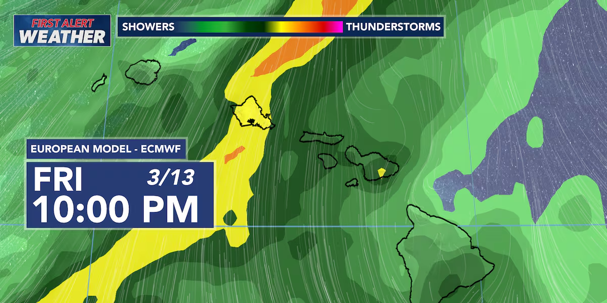
Afternoon: The deep tropical moisture is forecast to impact Oahu starting around midday and extend through the afternoon. Strong to severe thunderstorms, damaging south winds, and flash flooding will impact Oahu.
Night: The thunderstorms over Oahu will extend into the late evening and through the night. This slow-moving band of thunderstorms could lead to large amounts of rainfall dropping without much time for drainage, increasing the threat of flash flooding. Potentially damaging south winds will continue.
Saturday, March 14
Morning: The deep plume of tropical moisture will march towards Molokai and Lanai early Saturday morning. The most impactful weather will reach Maui by early morning to midday on Saturday. Again, winds will shift to be more southwesterly behind the line of thunderstorms for Oahu and Kauai. Lingering showers will be present for the western half of the state.
Afternoon: Thunderstorms will be present over the eastern half of the state throughout Saturday afternoon. The initial band of thunderstorms could stall over eastern Maui Saturday afternoon and evening.
Pop-up and more scattered thunderstorms are expected for Hawaii Island. However, strong south winds are still expected throughout Saturday for Hawaii Island. Current models hint at higher rainfall totals for the Kona side of Hawaii Island.
Night: The stalled band could remain between Maui and Hawaii Island throughout the night, exacerbating the flooding risk.
Sunday, March 15
The flooding threat will start to decrease for Kauai and Oahu throughout Sunday. However, the ground will be so saturated that any additional rainfall could lead to quick runoff and flash flooding.
Flash flooding and breezy southwest winds are still expected for Maui County and Hawaii Island on Sunday, potentially extending into Monday for Hawaii Island.
RELATED COVERAGE
Download the HNN Weather app from the Apple App Store or Google Play for the latest updates from your First Alert Weather Team: chief meteorologist Jennifer Robbins, meteorologist Drew Davis, and weather anchors Guy Hagi, Ben Gutierrez, and Billy V.

Copyright 2026 Hawaii News Now. All rights reserved.
Author
Related Posts

Siena coach Gerry McNamara: Focus on tournament, not Syracuse
David HaleMar 18, 2026, 12:52 PM ET Close College football reporter. Joined ESPN in 2012. Graduate of the University of Delaware. Multiple...
Read out all
Gasperini Previews “Do or Die” Fixture Against Bologna in EL Decider
With nine matches remaining in the 2025-2026 Serie A season, Roma may need nearly every single one of those 27 points to...
Read out all

US F-35 damaged by suspected Iranian fire makes emergency landing, sources say – CNN
US F-35 damaged by suspected Iranian fire makes emergency landing, sources say CNN Iran claims historic strike on US F-35 fighter jet Geo News...
Read out all
L’OL est sur les traces de Rihito Yamamoto
L’OL prépare la saison prochaine et tente de renifler les bons coups. Les recruteurs sont allés en Belgique pour observer Rihito Yamamoto...
Read out all
Six bets and an Eliminator pick for the first round of the men’s tournament
Mar 17, 2026, 12:33 PM ET The 2026 men’s basketball tournament is here! Throughout the tourney, Mark Zinno will provide his best...
Read out all