
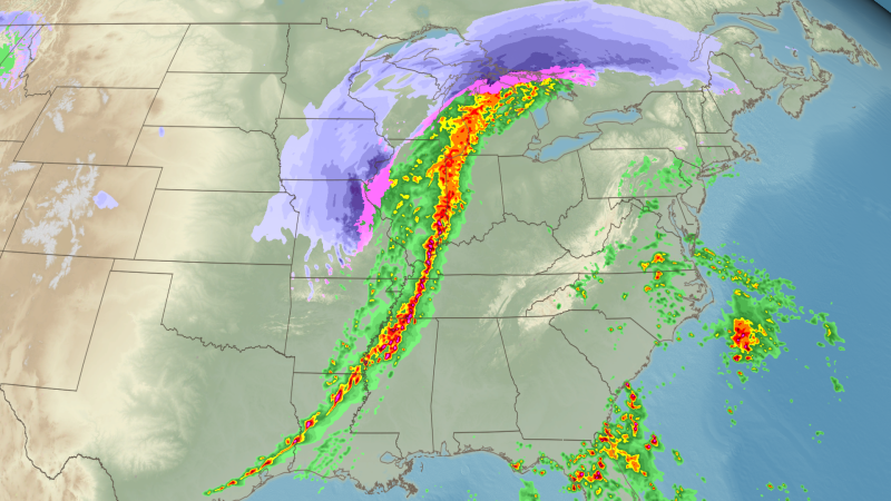
A massive storm system sweeping across the eastern US Sunday into Monday is unleashing severe storms with damaging winds while burying its northern side in heavy snow.
This storm has everything: feet of snow and blizzard conditions for parts of the Midwest and Great Lakes, roaring winds capable of knocking out power and elevating fire weather concerns in the Plains and Rockies, and thunderstorms that could unleash tornadoes and widespread damaging wind gusts.
The storm’s snowy side packed the most significant punch early Sunday for millions in the north-central US, with wind-whipped snow creating dangerous travel. But from late Sunday through Monday, more than 100 million people in the eastern half of the country are facing a significant severe thunderstorm and tornado risk.

Parts of Minnesota were covered in snow, with large areas under a blizzard warning issued by the National Weather Service.
A Level 3 of 5 risk of severe thunderstorms is in place from the Great Lakes to the Gulf Coast through Monday morning.
Damaging straight-line wind gusts past 60 mph are the most widespread threat with any severe thunderstorms through early Monday. Some areas from the Tennessee Valley into the Great Lakes could see even stronger gusts of 75 mph or more.
As of 1:30 a.m. ET Monday, there were nearly 340,000 customers without power across seven states, according to PowerOutage.us, including over 80,000 in Michigan, nearly 70,000 in Texas and about 50,000 in Mississippi and Ohio each.
Nearly 9 million are under tornado watches and another 9 million are under severe thunderstorm watches from the Gulf Coast to the Ohio Valley. Some twisters could be strong — capable of causing EF2 damage or greater.

Damaging thunderstorms will push east overnight and reach the Appalachians and East Coast by Monday morning. Some will likely still be severe at sunrise Monday, but an injection of energy arriving in the afternoon will give the storms a new, even more dangerous life.
A Level 4 of 5 risk of severe thunderstorms is in place Monday from the Carolinas to the Maryland-Pennsylvania border, with a wider Level 3 of 5 risk in place in surrounding areas.
Damaging straight-line wind gusts are again expected to be the thunderstorms’ most widespread impact, with gusts past 75 mph possible in storms from Georgia to Pennsylvania and New Jersey.
Maryland Gov. Wes Moore declared a State of Preparedness Sunday night ahead of the elevated storm threat expected across the state Monday, he said on X. In response, Baltimore County Executive Kathy Klausmeier said the county would be opening the Emergency Operations Center and the state’s Department of Emergency Management will be coordinating readiness efforts.
All Baltimore County Public School campuses and offices will close early Monday due to the storm, the district said in a post on X. District of Columbia Public Schools also announced campuses would close two hours early Monday, and afterschool and evening activities are canceled. Additionally, Richmond Public Schools will be closed Monday and classes will be virtual because of the storm, the district said in an Instagram post.
The largest school districts in Maryland and Virginia announced early dismissals, and school closures and delays have also been announced in Minnesota, Wisconsin, Alabama and Florida, CNN affiliates reported.
DeMatha Catholic High School in Hyattsville, Maryland, will be holding classes remotely Monday because of the severe conditions expected, the school said in a text alert.
“The weather forecast for tornado conditions is too dangerous for us to have buses and vans and student drivers on the road,” the text alert read.
The school reminded parents of a 2001 incident in which two sisters were killed when a tornado picked up their car at the University of Maryland.
While the southern, warmer side of the storm is generating severe thunderstorm concerns, the cold northern side has been busy generating a lot of snow.
More than a foot of snow buried parts of southern Minnesota and central Wisconsin by Sunday morning, with plenty more to come. Snow will continue through Monday for much of the Midwest and Great Lakes.
A snow emergency has been declared for Milwaukee County on Monday, after the weather service issued a Blizzard Warning for southeast Wisconsin until 4 p.m. Monday, County Executive David Crowley announced on X. Non-essential departments will be closed, including the Milwaukee County Courthouse and Milwaukee County Zoo, he said.
This storm could be the snowiest ever in cities like Rochester, Minnesota. Parts of the city picked up about a foot of snow by Sunday morning, with up to another foot possible by the time the storm comes to an end. Rochester’s heaviest snow was from a March 2005 storm that dropped 20 inches.
Authorities in Iowa announced Sunday I-80 is closed in both directions from the Iowa City area to near the Nebraska border.
In Wisconsin, many roads in the state’s northern counties were impassable Sunday, the state’s transportation department said, urging everyone in the region to avoid driving.
And in Michigan, state police said Sunday the Mackinac Bridge to the state’s upper peninsula was closed and roads across Cheboygan County, near the bridge, were “impassable.”
Parts of Michigan’s Upper Peninsula are forecast to end up with snow totals of more than 3 feet by Monday night.
Marquette, Michigan, is no stranger to high snow totals from lake-effect snow, but this storm could be one of its biggest ever. The city’s largest two-day storm total on record stands at about 32 inches from a March 1997 storm. It’s forecast to get anywhere from 2 to 4 feet of snow from the current storm.
And it’s not like this snow is falling in a peaceful winter wonderland — powerful winds are whipping it up to create dangerous whiteouts and longer-lasting blizzard conditions.
The punishing conditions are making travel extremely hazardous and could cause power outages to increase.
Blizzard warnings are in effect for more than 12 million people from the Dakotas and Nebraska to the Great Lakes Sunday. The warnings will continue into Monday for some, as the worst conditions slowly start to come to an end.
This story has been updated with additional information.


